Flat Earth Origins
Jun 14, 2019 20:02:42 GMT
Post by Admin on Jun 14, 2019 20:02:42 GMT
.

===============
Notes

The one topic I promised myself I'd never do....sigh....worth a facepalm

Flat earth is actually worth two facepalms though, ......and the reason is that with a nice examination of Mesopotamian and Egyptian astrometry, metrology, geodesy and mathematics, it turns out the claim our ancestors thought the entire earth is flat is simply not true to begin with
Not only is it not true, it's also easily shown by an examination of the mathematical conventions of Egyptian and Mesopotamian astrometry and geodesy
This means all the silly debates with flat earthers, all the laser experiments, all the Youtube videos...entirely unnecessary
So, 1 facepalm for academics and 1 facepalm for flat earthers
I'm going to expose this fallacy of " Flat earth " once and for all, since it is an academic poo that keeps getting kicked down the road
Since the claim about the ancients believing the the earth was flat actually originates not with " flat earthers ", but rather modern academics' teachings about our ancestors " crude / simple " beliefs ( Completely ignoring the work of respected math / science historians like Otto Neugebauer or Joran Friberg ), the foundation for the claims of the fruitcakes are actually fueled by the claims of the academics
This is slightly disturbing,..... like the blind leading the deaf
The Bible is the main literary source cited when attempting to provide an academically reviewed source, so we'll dissect that as well, using word etymologies
People, I've found, will oft readily exclaim things like " The ancients thought the earth was on the back of a turtle and they herded goats and lived in caves and thought God was thunder and and and ", then they clap each other on the shoulder and move on to something else, having satisfied themselves by merely agreeing with one another
It seems to be backed up by artwork depicting their supposed beliefs, this in turn has been with us for ages, and when the discussion turns to what the ancients believed, the images are relentlessly posted as " proof " of their beliefs
Google is full of these silly images that are merely modern artistic depictions of something not true
A rather bland source like Wikipedia will offer:
" The flat Earth model is an archaic conception of Earth's shape as a plane or disk. Many ancient cultures subscribed to a flat Earth cosmography, including Greece until the classical period, the Bronze Age and Iron Age civilizations of the Near East until the Hellenistic period, India until the Gupta period (early centuries AD), and China until the 17th century. The idea of a spherical Earth appeared in Greek philosophy with Pythagoras (6th century BC), although most pre-Socratics (6th–5th century BC) retained the flat Earth model. Aristotle provided evidence for the spherical shape of the Earth on empirical grounds by around 330 BC. Knowledge of the spherical Earth gradually began to spread beyond the Hellenistic world from then on "
This above quoted claim on Wikipedia is typical of the BS that people keep repeating. Ever take some time to look into where the majority of Greek mathematicians studied mathematics ?
Egypt, where they happened to have made geodesy rigorous circa 3,000 BC. If you doubt that, feel free to come up with a hypothesis covering how the ancients oriented buildings, temples, streets and roads to align with astronomical phenomenon without using systems of units for measurement that were designed for dimensional analysis in astrometry and geodesy
For some strange reason, no matter how hard you comb the the most excellent websites offered by schools and universities around the world, databases of ancient languages, you cannot a single text describing this so-called belief that the entire earth is flat
This should strike you as odd, because by rational logic, if the ancients believed such a thing, they would have left extensive written records of it. While we have extensive writings that were preserved, we have zero texts detailing this supposed flat earth
We have literally hundreds of thousand of cuneiform texts and scrolls / papyrii, in both private and public collections
I've asked flat earthers to produce such a text, but that never happens ( Surprise ! )
When I originally began to study metrology ( Measurement and units ) Egypt and Mesopotamia, but starting with units of measurement from the Bible, and working my way backwards from Greek and Hebrew measures, to Babylonian, then Egyptian, then Akkadian, then ultimately to Sumerian, I never did find a flat earth,.... what I did find...... was both a round earth and a flat earth implied in their systems of measurement, and the phrasing used in their mathematical texts dealing with geodesy and astrometry
Turns out what " flat " means, in the context of mathematical astronomy, is not what people have taken it to mean
It turns out, there actually was a " dome " and a " flat earth " the ancients believed in, except it turned out to be something called a " local horizontal coordinate system " in astronomy, which is a dome, more accurately a hemisphere, and has a flat plane for a base, which is properly called " the fundamental plane "
This is a very basic coordinate system that has been in use for thousands of years and still in use to this day. It's " local " ( To the observer ), meaning it can be used anywhere on the surface of the earth ( Spherical )
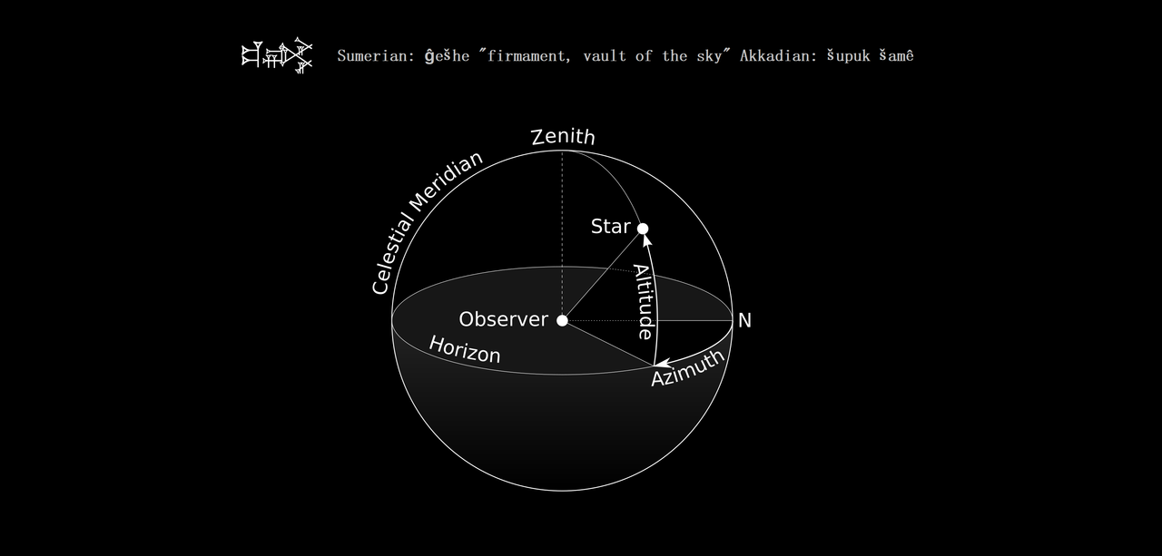
The fundamental plane in a spherical coordinate system is a plane of reference that divides the sphere into two hemispheres. The geocentric latitude of a point is then the angle between the fundamental plane and the line joining the point to the centre of the sphere

For a geographic coordinate system of the Earth, the fundamental plane is the Equator. Celestial coordinate systems have varying fundamental planes:
The horizontal coordinate system uses the observer's horizon
The Besselian coordinate system uses Earth's terminator (day/night boundary).[citation needed] This is a Cartesian coordinate system (x, y, z)
The equatorial coordinate system uses the celestial equator.
The ecliptic coordinate system uses the ecliptic.
The galactic coordinate system uses the Milky Way's galactic equator
So not only is the earth " round ", but it's also " flat " ( The fundamental flat plane of the horizontal coordinate system ) and due to the tricky nature of the definitions used in the context of mathematical astronomy as it was written in cuneiform or Egyptian scripts, people have really mangled the basis of it over a few thousand years
The " flatness " of " flat earth " ultimately comes from both the flat plane of the coordinate system, an idealized object that does not exist in the real world and the apparent visual flatness of what the observer standing on the plane sees
The " dome " was mainly for recording the positions of objects in the sky, using arcseconds and arcminutes, as seen from the middle of the visible horizon
It's how ancient priest-astronomers recorded positions, made predictions, recorded ephemerides, calculated times for rituals, etc, but also how they oriented certain buildings to align with certain astronomical events, like Karnak Temple or the Kaaba in Mecca
The observer would first establish the nadir and the zenith by the use of a weight on a string ( A pendulum )
Nadir is from the Arabic: نظير / ALA-LC: naẓīr, meaning "counterpart") and is the direction pointing directly below a particular location; that is, it is one of two vertical directions at a specified location, orthogonal to a horizontal flat surface there
" Orthogonal " means at a 90° cant

So it turns out the whole reason we find the flat plane associated with the hemisphere that forms the framework of the horizontal coordinate system is that in order to write down the positions of objects in the sky, you have to record the position relative to something else the observer sees in their field of vision, in this case the visible horizon, which appears to be flat and is represented in the base of the hemisphere as a flat plane
You have to treat the earth as a flat object, mathematically, to use this system so you can record positions of objects in the sky, but naturally it does not mean that the earth is actually flat, rather that it appears locally to be flat, ie relative to the observer, who would be standing in the middle of the flat plane of the " dome " to make their measurements
This horizontal coordinate system can be used anywhere on the surface of the earth
The local horizon extends into the plane of the astronomical horizon, and both are treated as flat objects


Another problem with the claim the ancients thought the entire earth was flat, is that we know for a fact Sumerian geodesy originally divided earth's latitude into seven zones between equator and pole

Distance units were geodectic as distinguished from non-geodectic basic length units
Unfortunately, for flat earthers, it's impossible to divide a flat plane into zones of latitude, but since no flat earther has ever bothered to actually study Mesopotamian geodesy, they're unaware of that little problem with their claims

Geographical latitude and longitude are stated in the units of degreea, minutes of arc, and seconds of arc, these originate with Mesopotamian and Egyptian systems of measurement.
They are angles, not metric measures, and describe the direction of the local normal to the reference ellipsoid of revolution

This is approximately the same as the orthogonal direction of the plumbline, i.e., local gravity, which is also the normal to the geoid surface
For this reason, astronomical position determination – measuring the direction of the plumbline by astronomical means – works fairly well provided an ellipsoidal model of the figure of Earth is used
The length of the Mesopotamian plumbline was 360 grains in length ( The grain being a fundamental unit of Naram-Sin's reformation of metrology ), which was approximately the length of the modern " seconds pendulum " that uses the meter ( Iow, they had known about this long before modern scientists )
With the moon being approximately 3 grains in apparent width, and the finger / horn being 6 in total
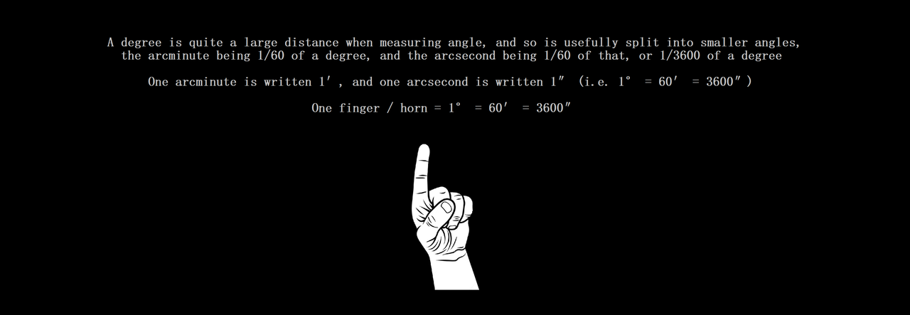
1° = 1 finger / horn = 3600 (Sar/Garden) arcseconds = 1 arcminute = 1/3600 of the moon's orbital path


The known frequency of the textual use of the unit of the " finger / horn ", illustrated below
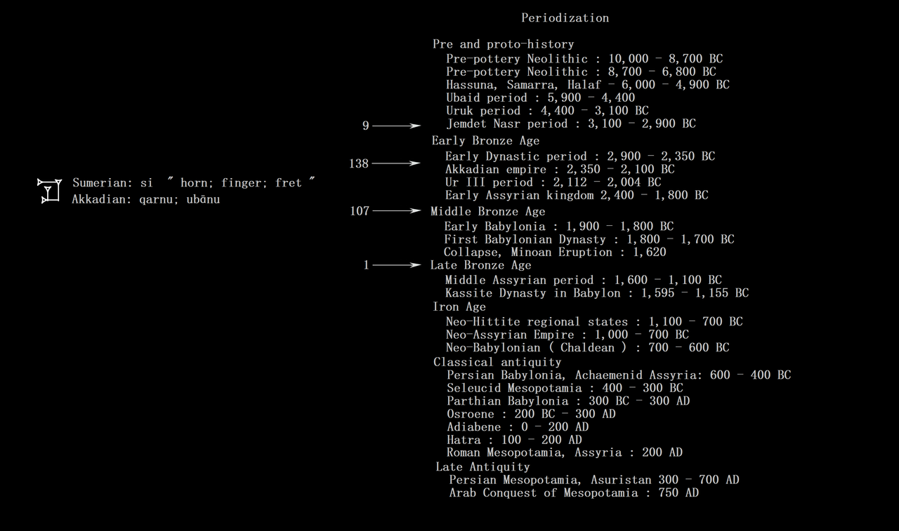
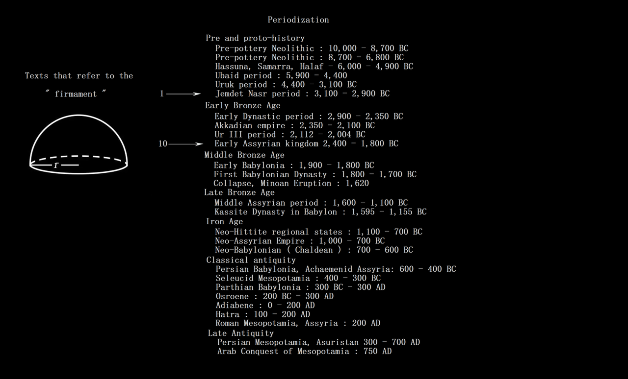
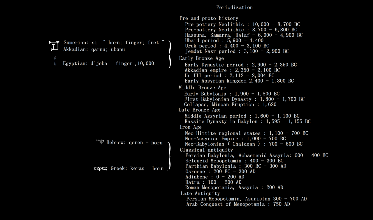
The periodization of the cognates from Sumerian, Egyptian, Akkadian, Hebrew and Greek

Flat earth is actually worth two facepalms though, ......and the reason is that with a nice examination of Mesopotamian and Egyptian astrometry, metrology, geodesy and mathematics, it turns out the claim our ancestors thought the entire earth is flat is simply not true to begin with
Not only is it not true, it's also easily shown by an examination of the mathematical conventions of Egyptian and Mesopotamian astrometry and geodesy
This means all the silly debates with flat earthers, all the laser experiments, all the Youtube videos...entirely unnecessary
So, 1 facepalm for academics and 1 facepalm for flat earthers
I'm going to expose this fallacy of " Flat earth " once and for all, since it is an academic poo that keeps getting kicked down the road
Since the claim about the ancients believing the the earth was flat actually originates not with " flat earthers ", but rather modern academics' teachings about our ancestors " crude / simple " beliefs ( Completely ignoring the work of respected math / science historians like Otto Neugebauer or Joran Friberg ), the foundation for the claims of the fruitcakes are actually fueled by the claims of the academics
This is slightly disturbing,..... like the blind leading the deaf
The Bible is the main literary source cited when attempting to provide an academically reviewed source, so we'll dissect that as well, using word etymologies
People, I've found, will oft readily exclaim things like " The ancients thought the earth was on the back of a turtle and they herded goats and lived in caves and thought God was thunder and and and ", then they clap each other on the shoulder and move on to something else, having satisfied themselves by merely agreeing with one another
It seems to be backed up by artwork depicting their supposed beliefs, this in turn has been with us for ages, and when the discussion turns to what the ancients believed, the images are relentlessly posted as " proof " of their beliefs
Google is full of these silly images that are merely modern artistic depictions of something not true
A rather bland source like Wikipedia will offer:
" The flat Earth model is an archaic conception of Earth's shape as a plane or disk. Many ancient cultures subscribed to a flat Earth cosmography, including Greece until the classical period, the Bronze Age and Iron Age civilizations of the Near East until the Hellenistic period, India until the Gupta period (early centuries AD), and China until the 17th century. The idea of a spherical Earth appeared in Greek philosophy with Pythagoras (6th century BC), although most pre-Socratics (6th–5th century BC) retained the flat Earth model. Aristotle provided evidence for the spherical shape of the Earth on empirical grounds by around 330 BC. Knowledge of the spherical Earth gradually began to spread beyond the Hellenistic world from then on "
This above quoted claim on Wikipedia is typical of the BS that people keep repeating. Ever take some time to look into where the majority of Greek mathematicians studied mathematics ?
Egypt, where they happened to have made geodesy rigorous circa 3,000 BC. If you doubt that, feel free to come up with a hypothesis covering how the ancients oriented buildings, temples, streets and roads to align with astronomical phenomenon without using systems of units for measurement that were designed for dimensional analysis in astrometry and geodesy
For some strange reason, no matter how hard you comb the the most excellent websites offered by schools and universities around the world, databases of ancient languages, you cannot a single text describing this so-called belief that the entire earth is flat
This should strike you as odd, because by rational logic, if the ancients believed such a thing, they would have left extensive written records of it. While we have extensive writings that were preserved, we have zero texts detailing this supposed flat earth
We have literally hundreds of thousand of cuneiform texts and scrolls / papyrii, in both private and public collections
I've asked flat earthers to produce such a text, but that never happens ( Surprise ! )
When I originally began to study metrology ( Measurement and units ) Egypt and Mesopotamia, but starting with units of measurement from the Bible, and working my way backwards from Greek and Hebrew measures, to Babylonian, then Egyptian, then Akkadian, then ultimately to Sumerian, I never did find a flat earth,.... what I did find...... was both a round earth and a flat earth implied in their systems of measurement, and the phrasing used in their mathematical texts dealing with geodesy and astrometry
Turns out what " flat " means, in the context of mathematical astronomy, is not what people have taken it to mean
It turns out, there actually was a " dome " and a " flat earth " the ancients believed in, except it turned out to be something called a " local horizontal coordinate system " in astronomy, which is a dome, more accurately a hemisphere, and has a flat plane for a base, which is properly called " the fundamental plane "
This is a very basic coordinate system that has been in use for thousands of years and still in use to this day. It's " local " ( To the observer ), meaning it can be used anywhere on the surface of the earth ( Spherical )

The fundamental plane in a spherical coordinate system is a plane of reference that divides the sphere into two hemispheres. The geocentric latitude of a point is then the angle between the fundamental plane and the line joining the point to the centre of the sphere

For a geographic coordinate system of the Earth, the fundamental plane is the Equator. Celestial coordinate systems have varying fundamental planes:
The horizontal coordinate system uses the observer's horizon
The Besselian coordinate system uses Earth's terminator (day/night boundary).[citation needed] This is a Cartesian coordinate system (x, y, z)
The equatorial coordinate system uses the celestial equator.
The ecliptic coordinate system uses the ecliptic.
The galactic coordinate system uses the Milky Way's galactic equator
So not only is the earth " round ", but it's also " flat " ( The fundamental flat plane of the horizontal coordinate system ) and due to the tricky nature of the definitions used in the context of mathematical astronomy as it was written in cuneiform or Egyptian scripts, people have really mangled the basis of it over a few thousand years
The " flatness " of " flat earth " ultimately comes from both the flat plane of the coordinate system, an idealized object that does not exist in the real world and the apparent visual flatness of what the observer standing on the plane sees
The " dome " was mainly for recording the positions of objects in the sky, using arcseconds and arcminutes, as seen from the middle of the visible horizon
It's how ancient priest-astronomers recorded positions, made predictions, recorded ephemerides, calculated times for rituals, etc, but also how they oriented certain buildings to align with certain astronomical events, like Karnak Temple or the Kaaba in Mecca
The observer would first establish the nadir and the zenith by the use of a weight on a string ( A pendulum )
Nadir is from the Arabic: نظير / ALA-LC: naẓīr, meaning "counterpart") and is the direction pointing directly below a particular location; that is, it is one of two vertical directions at a specified location, orthogonal to a horizontal flat surface there
" Orthogonal " means at a 90° cant

So it turns out the whole reason we find the flat plane associated with the hemisphere that forms the framework of the horizontal coordinate system is that in order to write down the positions of objects in the sky, you have to record the position relative to something else the observer sees in their field of vision, in this case the visible horizon, which appears to be flat and is represented in the base of the hemisphere as a flat plane
You have to treat the earth as a flat object, mathematically, to use this system so you can record positions of objects in the sky, but naturally it does not mean that the earth is actually flat, rather that it appears locally to be flat, ie relative to the observer, who would be standing in the middle of the flat plane of the " dome " to make their measurements
This horizontal coordinate system can be used anywhere on the surface of the earth
The local horizon extends into the plane of the astronomical horizon, and both are treated as flat objects
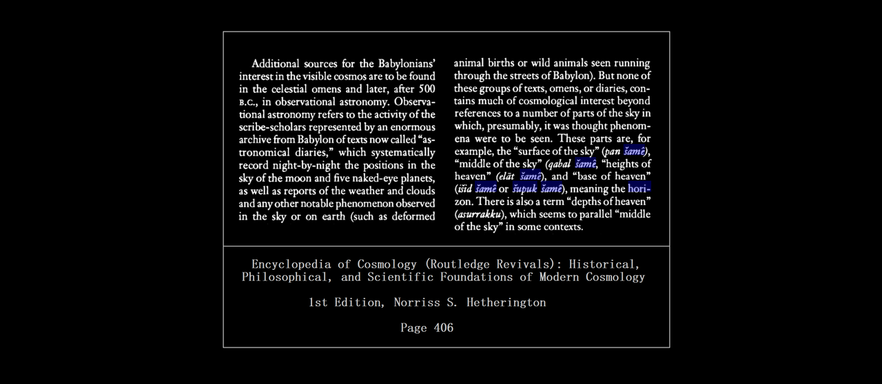
I've included a few book excerpts for the reader ( From Google previews )

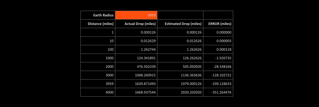
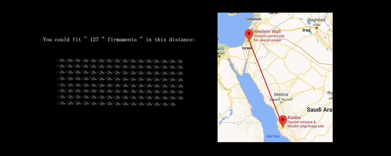
Using the firmament requires the observer first establish the distance to the horizon and the nadir / zenith

Calculating the distance to the horizon is simple:

The firmament was also known as the " highway of the heavens "

So, not only is the " firmament " a local horizontal coordinate system, meant to be used anywhere on the surface of the spherical earth ( Hence the " local " in the name ), it's apparent that " flat earthers " never bothered to investigate the history of such a thing to begin with

Another problem with the claim the ancients thought the entire earth was flat, is that we know for a fact Sumerian geodesy originally divided earth's latitude into seven zones between equator and pole

Distance units were geodectic as distinguished from non-geodectic basic length units
Unfortunately, for flat earthers, it's impossible to divide a flat plane into zones of latitude, but since no flat earther has ever bothered to actually study Mesopotamian geodesy, they're unaware of that little problem with their claims

Geographical latitude and longitude are stated in the units of degreea, minutes of arc, and seconds of arc, these originate with Mesopotamian and Egyptian systems of measurement.
They are angles, not metric measures, and describe the direction of the local normal to the reference ellipsoid of revolution

This is approximately the same as the orthogonal direction of the plumbline, i.e., local gravity, which is also the normal to the geoid surface
For this reason, astronomical position determination – measuring the direction of the plumbline by astronomical means – works fairly well provided an ellipsoidal model of the figure of Earth is used
The length of the Mesopotamian plumbline was 360 grains in length ( The grain being a fundamental unit of Naram-Sin's reformation of metrology ), which was approximately the length of the modern " seconds pendulum " that uses the meter ( Iow, they had known about this long before modern scientists )
With the moon being approximately 3 grains in apparent width, and the finger / horn being 6 in total
1° = 1 finger / horn = 3600 (Sar/Garden) arcseconds = 1 arcminute = 1/3600 of the moon's orbital path

The observer then uses these finger measurements (arcminutes and arcseconds) for astrometry

This system of using the human fingers as a measurement device in astrometry developed out of the intrinsic properties of the human eye and how it works with objects at various distances

There are optimal differences for viewing different things depending on the distance from the observer's eyes, this is the likely reason the principle unit of observation was then the finger:

The known frequency of the textual use of the unit of the " finger / horn ", illustrated below

The periodization of the cognates from Sumerian, Egyptian, Akkadian, Hebrew and Greek

===============
Notes


